


On this floor of Global Gallery (New Building), exhibits about the history of the development of Japanese science and technology are displayed. Since the Meiji Restoration, Japan has rapidly developed, absorbing Western science and technology. Now, Japan is one of the leading countries in the field of science and technology, and we are living on the benefit of that. However, in the core of it, there is Japan's own science and technology, which had been developed by people in the Edo Period when Western science and technology had not yet been adopted. These core technologies have been merged with Western science and technology, producing the present-day science and technology in Japan.
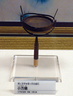
Shoho-gi (late Edo Period)
This is a compass consisting of gimbal structure, which was called "Wan Kara Shin" by Tadataka Inoh during his surveys across the country. Whichever direction you tilt the stick on which the compass is placed, the compass is kept in a horizontal position.
Ikemoto : In this section, exhibits about astronomy and surveying techniques in the Edo Period are displayed. In the Edo Period, many public works and river improvements were conducted. These projects were supported by accurate surveying techniques and astronomical observations. These are materials for astronomy at that time. Calendars in Japan were imported from China up until the early Edo Period, but the calendar called "Jokyo-reki" was created by the official astronomer of the shogunate, which then led to use of Japan's own calendars. These terrestrial globe and celestial globe were used for astro-nomy education of that time.
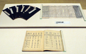
Here is the section of surveying techniques. When it comes to a survey, Tadataka Inoh should be remembered. This is a model of the quadrant used by Tadataka Inoh. It is very important to accurately observe celestial bodies in order to conduct land surveys. So, celestial bodies were observed by these tools when land surveys were conducted. Tadataka Inoh studied surveying techniques and astronomy while doing his family business in Sawara City, Chiba Prefecture. He apprenticed himself to Yoshitoki Takahashi when he was fifty years old, and started studying Western surveying techniques and astronomy. Then, he walked around the country and conducted land surveys for 16 years, from 1800 to 1816. This is "Ryoteisha," a kind of surveyor's wheel, used by Tadataka Inoh. Rotations of the wheels are utilized for measuring distance. However, considering road conditions at that time and errors of the wheels, it may not be possible to conduct accurate surveys. It can be said that this tool was made to indicate that surveys could be performed in this way. In those days, a variety of surveying tools were also imported from Western countries, and these reference books for survey became available.(continued in the right column)
These are surveying tools. This is a drafting instrument used for making reduced drawings from surveyed data. This is a measuring rope. Distance between two points could be measured by stretching the rope, which is marked off every 1.82m (1 Ken). Using these tools, geographical surveys of the country were carried out.
Naturally, surveys could not be conducted by Tadataka Inoh alone. It is considered that Tadataka took measurements of land while receiving supports from local people. It is said that there were local people who had basic knowledge of arithmetic and calculation at places where Tadataka and others visited. The fact that there were many people who acquired such an education in education systems at that time, including "Terakoya," a private elementary school in the Edo Period, was the basis for accomplishing this large project.
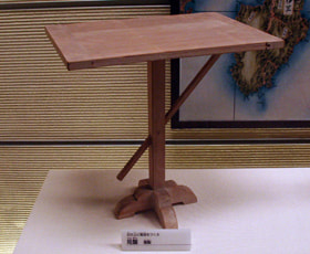
Kenban (reproduction)
The height of a target can be measured by making a similar triangle on the board.
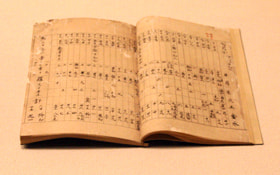
These are observation results of longitude and latitude, which were conducted by Tadataka Inoh. Even at that time, latitude could be accurately calculated by quadrants. Longitude was calculated by "Suiyo Kyugi," a kind of pendulum clock. The calculation by Suiyo Kyugi could result in making an error of several minutes per day, so Tadataka failed to calculate longitude in most cases. Only several points of longitude are recorded in this book.
"Shichiyo-reki" is a kind of astronomical calendar in which the movements of the sun, moon and five planets are described. This calendar ceased to be used in the Muromachi Period, but was reused in the calendar reform in the Jokyo Period, which was conducted by Harumi Shibukawa. This is Shichiyo Calendar for 1683. This type of calendar had been produced until the end of the Edo Period.

Shoho-gi (late Edo Period)
This is a compass consisting of gimbal structure, which was called "Wan Kara Shin" by Tadataka Inoh during his surveys across the country. Whichever direction you tilt the stick on which the compass is placed, the compass is kept in a horizontal position.