


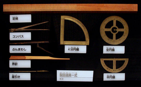
A set of drafting instruments used for making maps
Tadataka Inoh made a significant contribution to creating the map of Japan. While attending to his family business in "Shimosa no Kuni Sawara" (present-day Chiba Prefecture), Tadataka studied mathematics, land surveying and astronomy, and also composed Chinese poetry and comic haiku. His byname and literary pseudonym were "Shisei" and "Toga" respectively. He yielded the headship of his family when he was 50 years old, move to Edo, was apprenticed to Yoshitoki Takahashi and studied Western calendars and methods of surveying and drafting. In 1800, he asked the shogunate for permission to start surveying the southeast seashore of Hokkaido. Since then, he traveled around the country and conducted land surveys for 18 years. However, he died in 1818 at the age of 74 before completing a map of Japan.
The astronomical office of the shogunate took over the map making, and completed "Dainihon Enkaiyochi Zenzu," a map of Japan, in 1822. This map is also called "Nihon Yochi Zenzu" or "Jissoku Yochi Zenzu," but is popularly termed "Inoh-zu." The tomb of Tadataka Inoh is located at the graveyard of Genkuji Temple. His tombstone is engraved "Toga Inoh Sensei no Haka." His master, Yoshitoki Takahashi, died young at the age of 41. The tomb of Yoshitoki is also located at Genkuji Temple, and his tombstone is engraved "Toko Takahashi Kun no Haka." In accordance with Tadataka's will, he was buried beside his master. (Reference: Taito Meisho Zue)
The astronomical office of the shogunate took over the map making, and completed "Dainihon Enkaiyochi Zenzu," a map of Japan, in 1822. This map is also called "Nihon Yochi Zenzu" or "Jissoku Yochi Zenzu," but is popularly termed "Inoh-zu." The tomb of Tadataka Inoh is located at the graveyard of Genkuji Temple. His tombstone is engraved "Toga Inoh Sensei no Haka." His master, Yoshitoki Takahashi, died young at the age of 41. The tomb of Yoshitoki is also located at Genkuji Temple, and his tombstone is engraved "Toko Takahashi Kun no Haka." In accordance with Tadataka's will, he was buried beside his master. (Reference: Taito Meisho Zue)
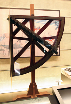
Medium-size Quadrant
The quadrant is an instrument carrying a quarter-circle arc, which is used for measuring the altitudes of astronomical objects. This quadrant was created by Shigetomi Hazama, a teacher of Tadataka Ino, referring to "Reidai Gishoshi (written by Ferdinand Verbiest in 1674) and other documents. There were two types of quadrants: a large quadrant with a radius of approximately 182cm, and a medium-size quadrant with a radius of approximately 115cm. Medium-size quadrants were used for surveys across the country.

Terrestrial Globe (made in the early 18th century)
This globe was created by Japanese. The map depicted on the globe is based on the world map created by Matteo Ricci, a Jesuit missionary. In Japan, the first terrestrial and celestial globes were created by Shunkai Shibukawa, an official astronomer of the shogunate, in 1690.

This globe was created by Japanese. The map depicted on the globe is based on the world map created by Matteo Ricci, a Jesuit missionary. In Japan, the first terrestrial and celestial globes were created by Shunkai Shibukawa, an official astronomer of the shogunate, in 1690.

Celestial Globe (1855)
Although Japanese astronomy in the Edo Period was influenced by Chinese astronomy, which used constellations unique to China, it can be considered that this celestial globe is based on "Gisho Kosei" published in 1752, which adopted Western astronomy. It is interesting to note that daily positions of Comet Donati, which appeared in 1858, are marked.

Although Japanese astronomy in the Edo Period was influenced by Chinese astronomy, which used constellations unique to China, it can be considered that this celestial globe is based on "Gisho Kosei" published in 1752, which adopted Western astronomy. It is interesting to note that daily positions of Comet Donati, which appeared in 1858, are marked.

Star Chart [reproduction] (1813)
This celestial map was drawn by Kanko Takamori. The Milky Way was also depicted with characteristic colors. Kanko was an expert at making instruments, and created many scientific instruments, including octants, quadrants, thermometers and astronomical clocks. Historical records report that Gennai Hiraga independently created "Erekiteru," a hand-operated electric generator, which he also repaired by himself.

This celestial map was drawn by Kanko Takamori. The Milky Way was also depicted with characteristic colors. Kanko was an expert at making instruments, and created many scientific instruments, including octants, quadrants, thermometers and astronomical clocks. Historical records report that Gennai Hiraga independently created "Erekiteru," a hand-operated electric generator, which he also repaired by himself.

Tenmon Seisho-zu [reproduction] (1966)
This is the first celestial map drawn by Japanese. Harumi Shibukawa also created "Tenmon Retsuji no zu" in 1670 and "Tenmon Bunya no zu" in 1677. Both of the maps are based on Chinese celestial maps, and the names of constellations are Chinese names. This celestial map includes 61 constellations and 308 stars, which were observed by Harumi.

This is the first celestial map drawn by Japanese. Harumi Shibukawa also created "Tenmon Retsuji no zu" in 1670 and "Tenmon Bunya no zu" in 1677. Both of the maps are based on Chinese celestial maps, and the names of constellations are Chinese names. This celestial map includes 61 constellations and 308 stars, which were observed by Harumi.

Kennawa [reproduction]
During the Edo Period, there were no optical surveying tools which Westerners had at that time. Therefore, Japanese surveyors paced off several hundred meters, or directly measured the distance by using "Kennawa," a measuring rope, "Kenjyaku," a measuring oak pole, "Takejyaku," a bamboo scale, and "Kusarijyaku," a measuring chain. These methods were not accurate and had a varying margin of error. In order to minimize errors Tadataka Inoh used Kusarijyaku, made of iron, for his survey across the country.

During the Edo Period, there were no optical surveying tools which Westerners had at that time. Therefore, Japanese surveyors paced off several hundred meters, or directly measured the distance by using "Kennawa," a measuring rope, "Kenjyaku," a measuring oak pole, "Takejyaku," a bamboo scale, and "Kusarijyaku," a measuring chain. These methods were not accurate and had a varying margin of error. In order to minimize errors Tadataka Inoh used Kusarijyaku, made of iron, for his survey across the country.

Ryoteisha used by Tadataka Inoh [reproduction]
Ryoteisha, a kind of surveyor's wheel, has a gear mechanism driven by wheels. Rotations of the wheels are utilized for measuring distance. Several types of Ryoteisha were created during the time of Tadataka Inoh. The source materials are owned by the Inoh Tadataka Museum in Sawara City.

Ryoteisha, a kind of surveyor's wheel, has a gear mechanism driven by wheels. Rotations of the wheels are utilized for measuring distance. Several types of Ryoteisha were created during the time of Tadataka Inoh. The source materials are owned by the Inoh Tadataka Museum in Sawara City.

Medium-size Quadrant
The quadrant is an instrument carrying a quarter-circle arc, which is used for measuring the altitudes of astronomical objects. This quadrant was created by Shigetomi Hazama, a teacher of Tadataka Ino, referring to "Reidai Gishoshi (written by Ferdinand Verbiest in 1674) and other documents. There were two types of quadrants: a large quadrant with a radius of approximately 182cm, and a medium-size quadrant with a radius of approximately 115cm. Medium-size quadrants were used for surveys across the country.